Yes!
There were difficulties because the survey coordinate system was different for each country.
I don't have any particular favorite apps.

The actual work period is about 5 months, but 5 years have passed with continuous upgrades.
Convenience when using in the field and accuracy of the calculation.
I have attached pictures to help users understand how to use the app. Also, level survey data can be shared between Android and iOS. It is a good app for anyone who is engaged in surveying, and I dare recommend it.
I don't have any special plans yet, but I plan to actively reflect the needs of users.
I think it's a must-have app for anyone engaged in surveying, and I think it's good to share good apps with each other.
About App:
This Measurement Application doesn’t need other notes or scientific calculators for measuring levels of something or EDM(Electric Distance Measurement device) measurement.
Capabilities of Measurement Application
> 36 languages are available
> Sound and operational(+-) support are available when there is the keypad input.
> When you enter a value of the level, the ground level is displayed immediately
> If you enter the final height, the difference between the ground height and the final height is displayed automatically.
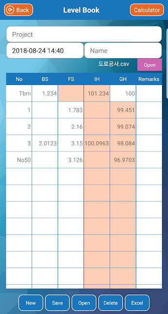
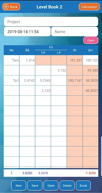
> The values of Level Measurement can be stored in the personal terminal and they can be saved as an Excel file.
> Automatic numbering of station numbers in leveling (When entering the enter key)
> Excel file can be imported and inputted when inputting coordinate value (long touch)
> You can get the distance and azimuth( Degree, Gradian, Radian) of two coordinates.
> If you know the coordinates of one point and azimuth and distance, you can calculate the coordinates of different points.
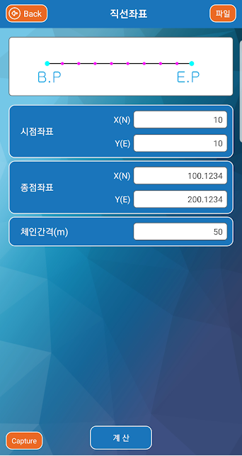
> If you know the coordinates of two points, you can get all coordinates on a straight line between two points.
> If you know the coordinates of two points, you can easily obtain the rectangular coordinates between two points.
> The coordinates of the center of two coordinates can be obtained.
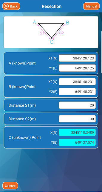
> If you know the coordinates of the two points, you can know the coordinates of the point that you do not know as a resection.
> The coordinates of the intersection of two straight lines can be obtained
> You can get the coordinates(x,y,z) of Slope
> All the coordinates of a straight line can be extracted and used as desired intervals.
> All the coordinates of a circle line can be extracted and used as desired intervals.
> All the coordinates of a clothoid line can be extracted and used at desired intervals.
> Display of X(N), Y(E), Z and X(E), Y(N), Z
Survey data can be shared
1. After downloading, select to share the file, open it in the app (survey) and save it
2. Paste the shared file to the app's storage folder
3. Android < ---- > iOS
Categories: Tools
Date: September 5, 2021
Developer: Shin Jong Soon
Website: https://blog.naver.com/sjos357